We’ve talked about ways of describing locations, using local, geocentric and geodetic coordinate systems. In the case of geocentric and geodetic coordinate systems we’ve been modeling the Earth as sphere or an ellipsoid.
This is fine if you have a globe on hand, but isn’t otherwise practical. Its much easier working with
flat maps, either printed on paper or displayed on a computer screen. In addition, latitude and longitude are angular measurements and thus tend to be more difficult to work with than more familiar cartesian x/y coordinates.
This is where projections come in – they convert points specified using some datum onto a flat surface. Since there is a lot of great information about projections on the web, I’ll just cover the very basics and link to sites with additional information.
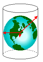
To create a projection we need to choose a projection surface – common ones are cylinders, cones and planes. For example, let’s say we decide to use a cylinder. First we project each point on the ellipsoid onto the cylinder.

Then we unroll the cylinder:

And now we have a map:

Two great sites for more information about projections are the US Government’s national atlas and Wikipedia.
Map Properties
No matter how you project points on the ellipsoid onto a flat surface you’ll end up with distortions and inaccuracies. More specifically, map properties that projections change include:
- Area
- Shape
- Scale
- Direction
- Distance
The key thing to understand about projections is that each one embodies a compromise between these properties. One projection may be designed to maintain shapes at the expense of areas while another one might maintain areas at the expense of shapes. As a result there are thousands of projections – each one designed to portray the Earth’s surface in a particular way.
To keep all these projections straight in your mind, it often helpful to categorize them. They can be categorized as conformal, equal area, equidistant or a compromise:
- Conformal projections maintain angular relations and thus shapes. Latitude and longitude lines intersect at right angles and the shapes of very small areas and angles with very short sides are preserved.
- Equal area projections maintain the relationships of areas. Thus the area a feature takes on a map is proportional to how much area the feature actually covers on the Earth’s surface.
- Equidistant projections preserve scale in the direction perpendicular to the line of zero distortion or radially outwards from a point of zero distortion.
- Compromise projections distort all map properties but only by a moderate amount.
Additional Resources
Wikipedia and the national atlas have great introductory articles to projections. Another great site is the Gallery of Map Projections which shows images of a number of projections.
If you really need to get deep into projections, then a classic text is Map Projections – A Working Manual by John Synder. This book is available online from the USGS (requires a plugin to read), and details a number of projections and the mathematical formulas behind them.
If you need to add projection support to your software, check out the Proj4 project, which is used by PostGis, or the closely related libproj4 project.
And if you have questions about projections, a great source of information is the proj4 mailing list.