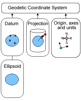
Its time to put together everything we’ve discussed in the last few posts. The following picture nicely summarizes the constituent parts of a geodetic coordinate system:

As you can see, a geodetic coordinate system consists of:
- A datum that provides a mathematical model of the Earth generally based on an ellipsoid
- A optional projection which maps coordinates from the ellipsoid surface onto a flat plane so they can be displayed on a paper map or computer screen
- An origin, axes and unit system
We’ve only briefly touched on the third part of a coordinate system, origins, axes and units, in our first post, so let’s take a look at those in more detail.
Axes
Generally axes point in compass directions, commonly east and north, and are aligned along a parallel (line of latitude) and meridian (line of longitude).
Origin
The location of a coordinate system’s origin is dependent upon the projection. Most projections specify a central meridian and a parallel – the intersection of the two is called the natural origin of the coordinate system.
It is common for the natural origin to be shifted. This is usually done to avoid negative coordinate values or extremely large coordinate values. Origin shifts are described using the terms False Easting and False Northing, where False Easting specifies an x offset and False Northing specifies a y offset. Note these values can be confusing – if the origin if shifted west (to the left), the False Easting is positive, not negative. This is easier to see in a picture:

A good example of a coordinate system with an origin shift is the British National Grid coordinate system. The natural origin is at 2°W, 49°N. However, the origin is shifted 400 kilometers to the west and 100 kilometers to the south so that most coordinate values are positive:

Units
Units are often measured in meters or miles, but can also be given as degrees of latitude and longitude.
Wrapping Up
We now know enough to dig into how Google Maps uses coordinate systems in our next post. Till then…
I’ve updated the first image at the request of a few readers to make the text larger. Hope this is better!